|
|
 |
|
|
 |
| Return to Latest Images index
|
06-Dec-2006
|
NASA Images Suggest Water Still Flows in Brief Spurts on Mars
Full Press Release
|
|
New Gully Deposit in a Crater in Terra Sirenum
|
|
Has liquid water flowed on Mars in this decade?
In June 2000, we reported the discovery, using the Mars Global
Surveyor's Mars Orbiter Camera, of very youthful-looking gullies found
on slopes at middle and high latitudes on Mars. Since that time, tens of
thousands of gullies have been imaged by all of the Mars orbiting
spacecraft: Mars Global Surveyor, Mars Odyssey, Mars Express and Mars
Reconnaissance Orbiter.
During the years since the original June 2000 report, the Mars
Global Surveyor's camera was used to test the hypothesis that the
gullies may be so young that some of them could still be active today.
The test was very simple: re-image gullies previously seen by the camera
and see if anything has changed.
In two cases, something changed. One of those cases is presented
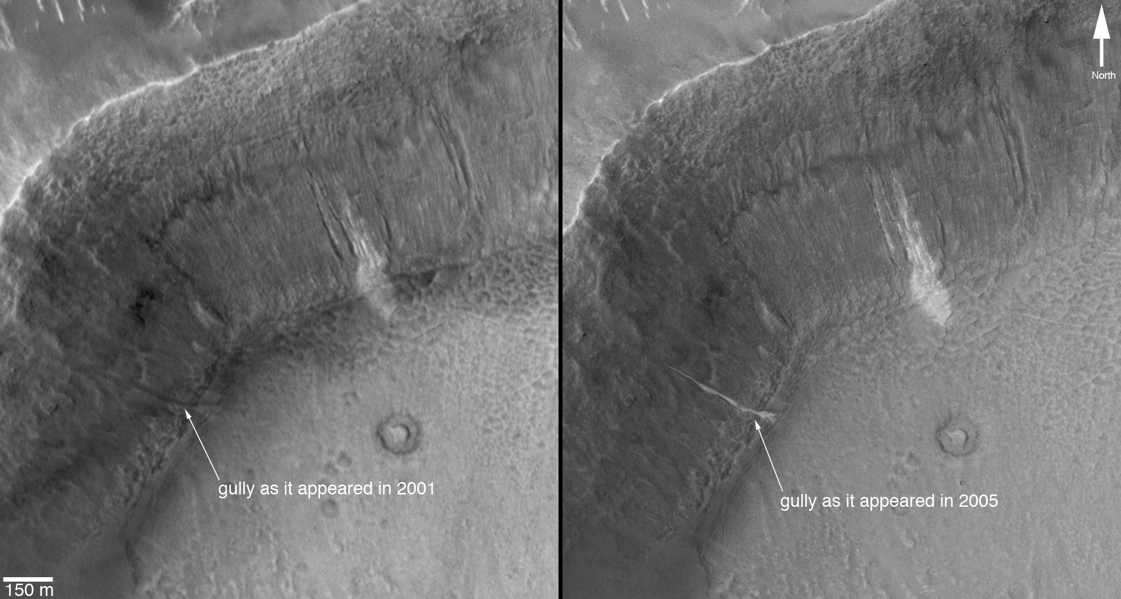
here. A gully on the wall of an unnamed crater in Terra Sirenum, at 36.6
degrees south, 161.8 degrees west, was initially imaged by the camera
on Dec. 22, 2001 (Figure A, left). It showed nothing noteworthy at the
location where a change would later be observed, but a group of nearby
gullies exhibited an unusual patch of light-toned material. As part of
our routine campaign to re-image gully sites using the camera, another
image of this location was acquired on April 24, 2005. A new light-toned
deposit had appeared in what was otherwise a nondescript gully (Figure
A, right). This deposit was imaged again by the camera on Aug. 26, 2005,
at a time when the sun angle and season were the same as in the
original December 2001 image, to confirm that indeed the light-toned
feature was something new, not just a trick of differing lighting
conditions. In August 2005, the feature was still present.
Figure A: This set of images shows a comparison
of the gully site as it appeared on Dec. 22, 2001 (left), with a mosaic
of two images acquired after the change occurred (the two images are
from Aug. 26, 2005, and Sept. 25, 2005). Sunlight illuminates each scene
from the northwest (top left). The 150-meter scale bar represents 164
yards.
Figure B: This is a mosaic of images that cover the
entire unnamed crater in Terra Sirenum. The location of the light-toned
gully deposits, old and new, is indicated. This is a mosaic of images
acquired by the camera in 2005 and 2006. The 500-meter scale bar equals
approximately 547 yards.
Figure C: This image shows an enlargement of a
portion of another image from August 2005, showing details of the new,
light-toned gully deposit. The new material covers the entire gully
floor, from the point at which the gully emerged from beneath a mantled
slope, down to the spot at which the channel meets the crater floor. At
this break in slope, the gully material, as it was emplaced, spread out
into five or six different fingers (this is called a "digitate"
termination as in finger digits). The 75-meter scale bar represents a
distance of about 82 yards.
Figure D: To confirm that the new, light-toned gully
deposit is not just a trick of changing illumination conditions as the
sun rises to different levels in the sky each season, the Mars Orbiter
Camera team repeatedly imaged this site throughout 2005 and 2006. Four
examples are shown here, acquired in April 2005, August 2005, February
2006 and April 2006. The "i=" indicates solar-incidence angle, or the
height of the sun in the local sky, relative to a case where the sun
would be directly overhead (i=0 degrees). Thus, the higher the incidence
angle, the lower the sun would appear in the sky to an observer on the
ground.
These images show that a material flowed down through a gully
channel, once between December 2001 and April 2005. After the flow
stopped, it left behind evidence -- the light-toned deposit. The deposit
is thin enough that its thickness cannot be measured in the camera's
1.5-meters-per-pixel images. However, it does exhibit a digitate
termination, suggesting that the material flowed in a fluid-like manner
down the approximately 25 degree slope before splaying out into multiple
small lobes at the point where the crater wall meets the crater floor
and the slope suddenly drops to near zero. This deposit, and a similar
one in a crater in the Centauri Montes, together suggests that the
materials involved were low-volume debris flows containing a mixture of
sediment and a liquid that had the physical properties of liquid water.
In this case, we propose that the water came from below the surface,
emerged somewhere beneath the mantle covering the original crater wall,
and then ran down through a previously existing gully channel. No new
gully was formed, but an old one was re-activated.
The light tone of the new gully deposit, and that of the older,
neighboring gullies, is intriguing. We cannot know from these images
whether the light tone indicates that ice is still present in and on the
surface of the deposit. Indeed, ice may not be likely: under present
conditions on the surface of Mars, ice would be expected to have
sublimed, or vaporized, away fairly shortly after the new deposit
formed. However, the light-toned material could be frost that forms and
re-forms frequently as trapped water-ice sublimes and "exhales" from
within the deposit. Alternatively, the light-tone may result if the
deposit consists of significantly finer grains (for example, fine silt)
than the surrounding surfaces, or if the deposit's surface is covered
with minerals such as salts formed as water evaporated from the
material.
Do these images prove that water has flowed on Mars? No, they
cannot. However, they provide the first very tantalizing evidence that
this may have occurred. While the surface environment on Mars is
extremely dry, drier than the most arid deserts on Earth, liquid water
from beneath the Martian surface may have come out of the ground and
flowed across this little portion of the red planet in this decade.
The Mars Global Surveyor mission is managed for NASA's Office of
Space Science, Washington, by NASA's Jet Propulsion Laboratory,
Pasadena, Calif., a division of the California Institute of Technology,
also in Pasadena. Lockheed Martin Space Systems, Denver, developed and
operates the spacecraft. Malin Space Science Systems, San Diego, Calif.,
built and operates the Mars Orbiter Camera.
For more information about images from the Mars Orbiter Camera, see http://www.msss.com/mgs/moc/index.html.
|
|
|
New Gully Deposit in a Crater in the Centauri Montes Region
|
|
Two Martian southern mid-latitude craters have new
light-toned deposits that formed in gully settings during the course of
the Mars Global Surveyor mission. Images from the Mars Orbiter Camera
documented one case in an unnamed crater in Terra Sirenum, described in
an accompanying release (see PIA09027 or MOC2-1618). The second case, in
an unnamed crater in the Centauri Montes region, east of the Hellas
Basin, is described here.
Gullies were first described by Mars Orbiter Camera scientists in
June 2000, and many examples were presented in our June 2000 web
releases and in a paper published in the journal Science. Additional
examples of these middle and high-latitude landforms can be seen among
the other more than 1,600 web releases.
The new gully deposit in an unnamed crater in the Centauri Montes
region is located near 38.7 degrees south latitude, 263.3 degrees west
longitude. Like the new gully deposit in Terra Sirenum, this one has a
light tone relative to its surroundings. It is on an equator-facing
slope on which numerous narrow gully channels occur. As this slope is
always in sunlight during the afternoons when Mars Global Surveyor
passes overhead, the gullies always appear somewhat "washed out," just
as craters on a full Moon do when viewed from Earth with a telescope.
 |
|
|
The new, light-toned flow was first noticed by the Mars Orbiter Camera
science operations team in an image acquired on Sept. 10, 2005.
Re-examination of other images of this crater showed that the new
deposit had actually been present on Feb. 21, 2004, when the distal
(down-slope) end of the deposit was captured in other images. In
February 2004, the deposit had gone unnoticed because only a small
portion of it was imaged. This location was first imaged by the Mars
Orbiter Camera on Aug. 30, 1999. The deposit was not present at that
time. Thus, it formed between Aug. 30, 1999 and Feb. 21, 2004.
Roughly 20 percent brighter than the surface as it appeared
before the flow occurred, the new deposit exhibits characteristics
consistent with transport and deposition of a fluid that behaved like
liquid water and likely transported some fine-grained sediment along
with it. The distal end of the flow broke into several branches, or
digits, and the material diverted and flowed around low obstacles. As
with the example in Terra Sirenum, the depth of the flow is too thin to
be measured in 1.5-meter-per-pixel (1.7-yard-per-pixel) images, so a
very small volume of liquid and sediment was involved. While the
material flowed and easily budded into several branches, it also must
have moved slow enough to not topple over some of the low obstacles in
its path.
Figure A: This figure shows the southeast wall of the
unnamed crater in the Centauri Montes region, as it appeared in August
1999, and later in September 2005. No light-toned deposit was present in
August 1999, but appeared by February 2004. The 300-meter scale bar
represents 328 yards.
Figure B: This picture is a colorized view of the
light-toned gully deposit, draped over a topographic image derived from
Mars Global Surveyor's Mars Orbiter Laser Altimeter data. The color
comes from a table derived from the colors of Mars as seen by the Mars
Reconnaissance Orbiter's High Resolution Imaging Science Experiment.
Figure C: The third figure is a mosaic of several Mars
Global Surveyor images, colorized using a table derived from Mars
Reconnaissance Orbiter camera color data and overlain on a sub-frame of a
Mars Odyssey Thermal Emission Imaging System image. The 1-kilometer
scale bar represents about 0.62 miles.
Figure D: The fourth figure is a colorized view
of the light-toned gully deposit as viewed from an oblique perspective,
draped over topography derived from Mars Global Surveyor's Mars Orbiter
Laser Altimeter data. The color comes from a table derived from the
colors of Mars as seen by the Mars Reconnaissance Orbiter camera.
The new light-toned flow, by itself, does not prove that liquid water
was involved in its genesis. However, this observation and the similar
light-toned flow in Terra Sirenum together show that some gully sites
are indeed changing today, providing tantalizing evidence there might be
sources of liquid water beneath the surface of Mars right now. In both
cases, these new flows may be indicating the locations of aquifers
(subsurface rocks saturated with water) that could be detected by
orbiting, ground-penetrating radar systems such as the Mars Express Mars
Advanced Radar for Subsurface and Ionosphere Sounding or the Mars
Reconnaissance Orbiter's Mars Shallow Subsurface Radar.
The Mars Global Surveyor mission is managed for NASA's Office of
Space Science, Washington, by NASA's Jet Propulsion Laboratory,
Pasadena, Calif., a division of the California Institute of Technology,
also in Pasadena. Lockheed Martin Space Systems, Denver, developed and
operates the spacecraft. Malin Space Science Systems, San Diego, Calif.,
built and operates the Mars Orbiter Camera.
For more information about images from the Mars Orbiter Camera, see http://www.msss.com/mgs/moc/index.html.
|
|
|
Groundwater May be Source for Erosion in Martian Gullies
|
|
Since their discovery early during the Mars Global
Surveyor's Mars Orbiter Camera investigation, as first reported in June
2000, Martian gullies have presented a puzzle for the Mars science
community: what fluid was responsible for the erosion that created the
channels, and where did it come from? The gullies seem to be quite young
in a geologic sense (millions of years or less), yet modern and
geologically-recent Mars is an extremely dry place, where water ice
sublimates directly to gas when the temperature is warm enough.
Since June 2000, many hypotheses have been
discussed at scientific meetings, in the scientific journals and
elsewhere. The original June 2000 hypothesis held that the fluid was
liquid water (either pure, salty, acidic, etc.) that came to the surface
where slopes intersected conduits of groundwater. Such slopes include
crater walls, valley walls, hills, massifs and crater central peaks.
Later investigators explored the possibility that rather than liquid
groundwater, the source was ground ice, which, under some climate
conditions, melted to produce liquid runoff. Still others noted that
thick mantles covered a fraction of the gully-bearing slopes, suggesting
that the mantles were ancient, dust-covered snow or ice packs that
might melt at the base to make liquid water runoff. Water was not the
only fluid considered by various colleagues; carbon dioxide can be fluid
at some pressures and temperatures. Fluid carbon dioxide was also
proposed as a candidate fluidizing agent. Even dry mass movement, or
land sliding, of unconsolidated granular material can exhibit some
fluid-like behavior. Such mass movements were considered as an
explanation for the gullies.
The presence of channels primarily formed by erosion but also
displaying features representing along-channel deposition, such as
levees and meanders, and terminal depositional aprons consisting of
dozens to hundreds of individual flow lobes, contributed to the general
acceptance of the hypothesis that gullies involved the action of liquid
water.
Throughout the Mars Global Surveyor mission, the Mars Orbiter
Camera team continued to image gullies at every opportunity, looking for
new gullies, taking higher resolution images of previously identified
gullies, and monitoring the gullies for changes that might occur. Among
the results of this extensive survey are numerous examples of gullies
that have geological relations to other things in their vicinity. This
provides support for the hypothesis that the fluid responsible for the
gullies came from beneath the ground, either as groundwater or melting
of ice in the Martian subsurface. Three of the best examples are
presented here.
Figure A: The first picture shows a pair of
gully channels that emerge, fully-born at nearly their full width, from
beneath small overhangs on the north wall of Dao Vallis. These overhangs
are probably created by the presence of a hard-rock layer. Liquid,
probably water, percolated through permeable layers just beneath these
harder, more resistant rock layers. The arrow points to the place where
one of the two neighboring channels emerges. This is a sub-frame of an
image acquired on Jan. 10, 2006, located near 34.2 degrees south
latitude, 268.1 degrees west longitude. The 150-meter scale bar is about
164 yards wide.
Figure B: The second picture shows a gully that formed
on the wall of a crater that intersected a mare-type ridge. The term,
mare, is from the dark volcanic plains of Earth's moon, for example Mare
Tranquilitatis was the plain on which the Apollo 11 crew landed in
1969. The lunar maria (maria is the plural form of mare), when viewed
from above, have many "wrinkle" ridges. These ridges are the surface
expression of thrust faults. The mare-type ridge in the picture shown
here is thus the product of faulting, as rocks on the west (left) side
of the image were thrust toward the east (right). Finding a gully
associated with a fault is excellent evidence for the groundwater
hypothesis, because ground water percolates through cracks and pores in
the ground. On Earth, springs (where groundwater comes to the surface)
are often found along fault lines. What is most important about this
particular Martian gully is that it occurs equatorward of 30 degrees
south, which is extremely unusual. The only gully in this crater is the
one associated with the fault. It is essentially the site of a spring,
now dried up perhaps. This picture is a sub-frame of an image located
near 29.1 degrees south latitude, 207.5 degrees west longitude, acquired
on Jan. 17, 2005.
Figure C: The third picture shows a small crater on the
rim of a larger crater. Only a small portion of the wall of this larger
crater is captured in the image. Immediately beneath the small crater
occurs a group of gullies. The presence of these gullies also supports
the groundwater hypothesis because impacting meteors will fracture the
rocks into which they form a crater. In this case, there would be an
initial set of subsurface fractures caused by the large impact that
created the original, large crater. Then, when the smaller crater
formed, it would have created additional fractures in its vicinity.
These extra fractures would then have provided pathways, or conduits,
through which ground water would come to the surface on the wall of the
larger crater, thus creating the gullies observed. One might speculate
that the group of gullies was formed by the impact that made the small
crater, because of the heat and fracturing of rock during the impact
process. However, the gullies are much younger than the small crater;
the ejecta from the small crater has been largely eroded away or buried,
and the crater partially filled, while the gullies appear sharp, crisp
and fresh. This is a portion of an image located near 33.9 degrees south
latitude, 160 degrees west longitude, acquired on March 31, 2006.
The Mars Global Surveyor mission is managed for NASA's Office of
Space Science, Washington, by NASA's Jet Propulsion Laboratory,
Pasadena, Calif., a division of the California Institute of Technology,
also in Pasadena. Lockheed Martin Space Systems, Denver, developed and
operates the spacecraft. Malin Space Science Systems, San Diego, Calif.,
built and operates the Mars Orbiter Camera.
For more information about images from the Mars Orbiter Camera, see http://www.msss.com/mgs/moc/index.html.
|
|
|
JPL Image Use Policy
|


